Dependable Aerial Solutions for Your Business
End-to-end Drone solutions business that offers High Quality Aerial Imagery and mapping products, Data Analysis, GIS, and Software Solutions.
End-to-end Drone solutions business that offers High Quality Aerial Imagery and mapping products, Data Analysis, GIS, and Software Solutions.
Our professional Drone Imagery will provide you with a unique way to showcase your product or service.

Captivate, inspire and spark emotion through stunning Cinematography and photography. Give your audience a fresh perspective and looking by capturing your locations from the air.
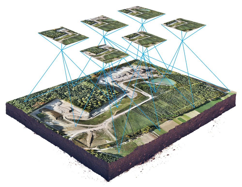
Jacksons Drones specializes in providing high-precision drone mapping services to a wide range of industries. Using cutting-edge drone technology and advanced mapping software, we can create detailed 2D and 3D maps of any area, quickly and efficiently. Our maps are highly accurate and include a variety of information such as elevation, vegetation, and man-made structures

From beautiful aerial photography to high-quality inspection grade images, we conduct aerial imagery for marketing material, inspections, Insurance, digital documentation, and job site progress. We also build unique deliverables to suit your needs.


These services can include mapping and spatial analysis, data management, and custom application development, among others. By leveraging GIS technology, small businesses can gain valuable insights into their operations, customers, and markets, and make data-driven decisions that lead to increased efficiency and profitability.
These services can include drone training, flight planning, data processing, and analysis, as well as the development of custom drone-based solutions to meet the specific needs of clients. By working with a drone consulting business, local businesses and governments can gain access to cutting-edge technology and expertise, allowing them to take advantage of the many benefits of drones, such as increased efficiency, cost savings, and improved decision making.

Jacksons Drones can provide a variety of data analytics services to customers using the data collected by drones or UAVs. These services can include the creation of detailed maps, 3D models, and other visualizations, as well as the analysis of data using advanced algorithms and machine learning techniques. Customers can use this data to gain insights into their operations, identify trends and patterns, and make data-driven decisions. Some of the examples of applications that a drone business can offer are, crop health analysis, site inspections, volumetric calculations and even thermal imaging. By providing data analytics services, a drone business can help customers to better understand their operations and make informed decisions that lead to increased efficiency and profitability.
High-resolution aerial imagery and 3D mapping: Collecting high-resolution imagery and creating 3D models of an area using drones, which can be used for a variety of applications including land use planning, construction site management, and asset inspection.
Environmental monitoring and management: Using drones equipped with sensors such as thermal cameras, air quality sensors, and multispectral cameras to monitor wildlife populations, track changes in land use, and assess the health of ecosystems.
Vegetation Management / Forestry: Using drones equipped with multispectral cameras to identify areas of a crop field that are experiencing stress, such as disease or pest infestations, to optimize crop management and increase yields.
Aerial Surveying and inspection: Using drones to inspect and survey hard-to-reach or dangerous areas such as bridges, power lines, and industrial facilities.
Search and Rescue: Using drones equipped with cameras and thermal imaging to locate missing person or to assess damages after a natural disaster.
Emergency response: Using drones to assess damage and monitor emergency situations such as wildfires and floods.
Volumetric calculations: Using drones to measure the volume of stockpiles, mining pits, and other areas to track inventory.
Inspection and maintenance: Using drones to inspect and maintain infrastructure such as wind turbines, oil and gas pipelines and powerlines.
Solar Panel Inspection: Drones are increasingly being used to inspect solar panel arrays, providing a cost-effective and efficient way to collect high-resolution imagery and detailed data on the performance and condition of solar panels. This allows for early identification of any issues such as soiling, shading, or damage, which can help to optimize energy production and reduce maintenance costs.
Located in the Silicon Valley.